
What will you receive in your geotechnical report?
Discover exactly what a geotechnical report includes: stratigraphy, foundation parameters, the groundwater level and more. A complete guide for homeowners.

Imagine that you hire someone to build the foundations of your house and they tell you: "No need to look at the ground, I already know what the soil is like around here." That sounds absurd, doesn’t it? Well, that is exactly what happens when construction is carried out without a geotechnical study. And it happens more often than you might think.
A geotechnical report is not just another piece of bureaucratic paperwork. It is the document that determines whether your home will settle or sink, whether the foundations cost €20,000 or €80,000, and whether the concrete will stand up for decades or deteriorate in just a few years due to the aggressiveness of the groundwater. And yet many homeowners commission it without knowing what they are going to receive.
This guide exists precisely for that: so that when you open that dossier, you know how to read each section, understand why it is there, and can demand what you are entitled to.
A legal and technical document, not a simple summary
The first thing to understand is that a geotechnical report is not a four-page PDF with photos of the ground. It is an exhaustive technical document with legal validity, required for the construction of dwellings and governed by the Technical Building Code (CTE), specifically its Basic Document for Structural Safety.
For it to have that validity, it must be signed by a competent professional — usually a geologist or a engineering geologist — and, in most autonomous communities, visa-stamped by their professional college. Without that signature and visa-stamp, your architect cannot attach it to the execution project, and the work lacks solid documentary backing.
A geotechnical report is the instruction manual your architect needs in order to calculate the foundations without oversizing them or cutting corners where they must not be cut.
This matters more than it seems. A report without a visa-stamp can be rejected by the town hall, by the insurer, or by the bank if you apply for a mortgage. And a poorly carried out report — or directly falsified — can leave your architect without real data, with everything that implies for the safety of the structure.
👉 Who signs the geotechnical report and why does that signature change everything?
Report anatomy: what you will find, section by section
A well-prepared geotechnical dossier has a predictable structure. Knowing it will help you spot if something important is missing or if the technician has just done the bare minimum.
-
01
Descriptive report
Data for your plot: location, cadastral reference, general characteristics of the surroundings, and description of the proposed project (number of storeys, whether there will be a basement, estimated loads). This is the cover sheet for the work.
-
02
Fieldwork and laboratory work
The exact detail of what was done on the ground: number of mechanical boreholes, static or dynamic penetration tests (SPT, DPSH), manual trial pits. It includes the exact coordinates of each test point and the laboratory analyses carried out on the samples extracted.
-
03
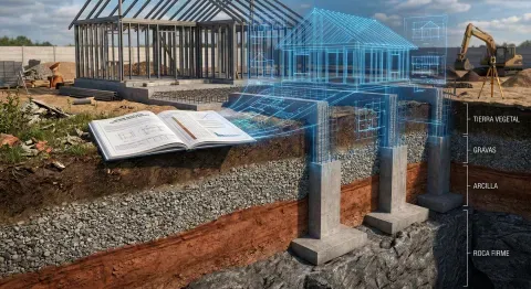
Stratigraphy and groundwater levelThe subsurface “section”: layer by layer, what materials are present (clays, gravels, rock), the thickness of each, and at what depth groundwater appears, if it exists. It is the three-dimensional map of the ground beneath your plot. -
04
Geotechnical parametersThe numbers that say it all: permissible soil bearing stress, expansivity of the clays, aggressiveness of the water and the soil towards the concrete, and seismic coefficients according to NCSE-02 regulations. These are the data that the structural designer inputs into their models. -
05
Conclusions and foundation recommendationsThe most important section. The geologist determines what type of foundation is most suitable (isolated strip footings, continuous footings, foundation raft, piles), the exact depth to which it must bear, and what settlements — small differential settlements — may be expected in the long term. -
06
Documentary annexesOfficial laboratory records, graphs of the boreholes (lithological columns), situation plans of the tests, and photographic coverage of the fieldwork. Proof that everything claimed in the report really took place.
👉 How many boreholes does my plot need for the geotechnical study?

The case that explains everything: when the ground lies
In an urban development on the outskirts of Valencia, a small developer decided to save money on the geotechnical study. They commissioned the legal minimum: one borehole and one penetration test. The dwelling was built on what appeared to be firm ground. Two years later, cracks appeared in the façade. The diagnosis: an undetected pocket of expansive clay beneath the foundation level. The cost of the structural repair exceeded the original budget for the foundations.
The parameter that would have prevented all of this is the expansivity index of the clays, which appears in the geotechnical parameters section. A single laboratory test on the sample extracted during the borehole. Test price: less than €200. Cost of not having done it: tens of thousands.
Key data
The permissible soil bearing stress can vary between 0.5 kg/cm² in soft clays and over 4 kg/cm² in sound rock. That difference can triple the foundation cost if it is not detected in time.
👉 How does permissible bearing stress affect the foundation budget?
Three things you should check before accepting the report
Not all reports are the same. There are studies carried out with rigour, and studies that do the bare minimum to satisfy the paperwork. Before you consider the document you receive to be valid, check these three points:
1. Coordinates of the test points. Each borehole, trial pit, or penetration test must have exact UTM coordinates in the report. If they do not appear, there is no way to verify that the work was carried out where it claims. It is the equivalent of a medical blood test that fails to identify the patient.
2. Original laboratory records. The geotechnical parameters must be supported by the corresponding laboratory tests. If the report includes resistance or expansivity values but there are no attached records, those data lack traceability.
3. Foundation level recommendation. This is the piece of information with the greatest impact on the construction budget. It must appear explicitly, with a specific depth. A report that says “it is recommended to found on the competent stratum” without specifying the level is ambiguous and incomplete.
👉 What is the foundation level and why does it matter?
A geotechnical report without laboratory records is like a blood test without reference values: it has the form of a technical document, but it lacks real validity.
Now you know what you need to demand
A geotechnical report is not an expense. It is the investment that protects all the other costs of the project. Once you know what type of ground you have, how deep the water is, and what bearing stress the soil can take, your architect can size the foundations with surgical precision: no more and no less than what is necessary. That translates directly into money.
And now that you know the document’s anatomy, you can read it with different eyes. Not as a bureaucratic requirement that you sign without understanding, but as the map that determines the safety and cost of your future home.
The next step is clear: if you still do not have your geotechnical study, or if you have doubts about whether the one they provided meets all the sections we have seen here, it is time to sort it out.
Do you need your geotechnical report?
Request a quote with no obligation. We will explain exactly what your study will include and in how many days it will be ready and visa-stamped.


