What is the foundation level and why can an error in that figure ruin your build?
What is the foundation level, how is it determined in the geotechnical report, and why getting that figure wrong can drive up the cost of your project.

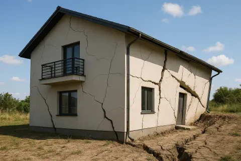
There is a piece of information in the geotechnical report that very few property owners know by name, but which lies behind almost all serious economic surprises that occur during the excavation phase. It is not a difficult concept. It is simply a depth: the distance from the ground surface to the exact level at which the footings for your home must bear. It is called the foundation level, and when that figure is calculated incorrectly —or is directly missing from the report— the consequences are measured in weeks of delay and in thousands of euros of cost overruns.
What makes this parameter especially treacherous is that its error is not discovered in the architect’s office or in the geologist’s consulting room. It is discovered once the excavator is already working, when the ground that appears at the planned depth is not the one it should be, and when modifying the foundations on the fly means redesigning, re-pricing and re-executing with the work already under way. At that point, negotiating from a position of strength is impossible.
What the foundation level exactly means
The foundation level is the minimum depth at which the base of the foundation elements must be located —isolated footings, raft slab or pile caps— so that they bear on ground with adequate and stable long-term bearing capacity.
It is not an arbitrary value or a conservative estimate on the high side. It is the result of combining three pieces of information that only the geotechnical study provides: the ground stratigraphy, the allowable stress of each stratum, and the depth at which the competent material appears where support can be achieved with guarantees.
Put practically: if the report states that the foundation level is 1.5 metres below, it means the foundations must bear 1.5 metres below the ground formation level. If the architect decides to found at 1 metre because, visually, the soil appears firm, they are making a structural decision without technical backing. And if the geologist has not specified that foundation level in the report, the architect has no documentary basis to justify any decision before the professional body, the town hall, or a potential claim for structural pathology.
👉 What does a geotechnical report contain? the cost of the work."
There are three main factors that determine the depth at which the geologist sets that foundation level. The first is the presence of competent strata: you have to reach the material with sufficient allowable stress for the loads envisaged. The second is the frost depth, relevant in inland areas with harsh winters, where the near-surface ground can undergo expansion and contraction cycles that destabilise shallow foundations. The third is the groundwater level: founding below the groundwater means special construction measures that significantly increase the cost of the project.
👉 How does the allowable stress affect the foundation cost?
How a poorly defined foundation level becomes an on-site construction problem
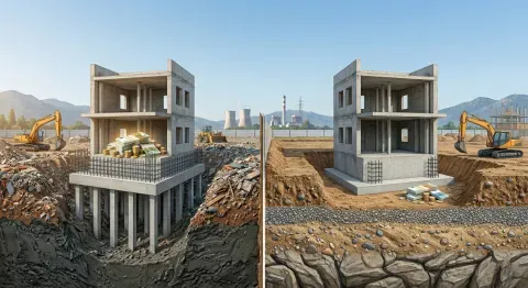
The relationship between foundation level and budget is direct and brutal. Each additional metre of depth means more excavation, more volume of concrete, more working time and, in some cases, the need for shoring or dewatering. In a standard single-family home, the difference between founding at 80 centimetres and founding at two metres can mean between €8,000 and €18,000 additional in the project budget.
When the foundation level is deeper than planned
This is the most common and most expensive scenario. The report did not specify the foundation level or estimated it in a vague way; the architect calculated the foundations at a reasonable depth based on their experience in the area, and during excavation the competent ground appears deeper than expected. The work stops, the designer has to resize, the contractor renegotiates prices, and the owner absorbs a cost overrun that no one had allowed for.
When there is variability between locations
On plots with irregular stratigraphy, the foundation level can vary across different areas within the same building footprint. One end of the dwelling may require founding at 1.2 metres, while the other needs to reach 2.5 metres. If the report does not reflect that variability clearly, the foundation system is designed uniformly and execution generates conflicts and unforeseen adjustments.
"The foundation level is not an indicative recommendation: it is the piece of information that turns the geotechnical report into an engineering document with real consequences for safety and
When the foundation level intersects the groundwater level
If the foundation level determined by the stratigraphy coincides with or lies below the groundwater level detected in the boreholes, the work requires waterproofing and drainage measures that are not always included in the budget. Founding in the presence of water without the appropriate measures is one of the most common causes of pathologies in basements and ground floors.
👉 How many boreholes does my plot need for the geotechnical study?
KEY DATA: In projects where the foundation level was not correctly defined in the geotechnical report, the average cost overrun for unforeseen items relating to excavation and foundation redesign is between 15 % and 35 % of the initial structural budget. For a home with a structural budget of €80,000, that means between €12,000 and €28,000 not foreseen.
The case of the home that ended up without a basement
On a plot in the Sierra de Guadalajara, a couple had designed their home with a basement for a garage. The geotechnical report they had commissioned indicated favourable ground without explicitly specifying the foundation level. The architect interpreted that it was possible to excavate down to the planned basement level, at three metres depth.
At 1.8 metres, rock appeared. Not the type of rock that represents ideal competent ground, but an exposure of fractured granite with pockets of clay within the discontinuities. Excavating in rock required means that the contractor had not arranged: breaker hammers, management of special waste, and a cost overrun of €14,000 just for excavation. The basement was removed from the project to avoid taking on that cost, which forced a redesign of the entire internal layout of the dwelling.
A geotechnical report that had included the foundation level precisely —and that had warned of the presence of rock at less than two metres— would have allowed that decision to be taken in the architect’s office, with time and without pressure. Instead, it was taken with the excavator halted and the contractor waiting.
👉 Who signs the geotechnical report and why does that signature change everything?
"Removing the basement from a home because the ground would not allow it was a perfectly valid decision. Taking it with the work already started, however, was a decision that cost time, money and a complete redesign."
Three signs that your report does not define the foundation level properly
Before considering the geotechnical report valid and passing it on to your architect, check that it does not include any of these three common mistakes:
- Vague wording without a specific depth. Statements such as "it is recommended to found in the competent stratum" or "the foundations must reach the gravel layer" without specifying a depth in metres are unacceptable. The report must state an explicit numerical foundation level, referenced to the ground formation level or to a fixed point on the plot.
- A single foundation level for the entire plot without justification. If the boreholes show stratigraphic variations between points and the report proposes a single foundation level for the entire building footprint, you need to ask why. In homogeneous ground it is reasonable; in ground with lateral variability it is a simplification that can generate problems on site.
- Absence of reference to the groundwater level in relation to the foundation level. If the report detects groundwater but does not explicitly relate that level to the recommended foundation level, critical information is missing. Your architect needs to know whether the foundation will be placed above, at the same height as, or below the water in order to size correctly the necessary construction measures.
The number that really defines where your home begins
In the end, the foundation level is the answer to a very specific question: how far do you have to excavate for the foundations of your home to sit on safe ground? It is a number. One and a half metres, two metres, three metres. But that number has consequences that extend across the entire project budget, across the structural design and across the safety of the building over decades.
When that number is correctly defined in the geotechnical report, your architect can calculate with precision, your contractor can price without excessive uncertainty margins, and you can plan your work without fear of surprises beneath the ground. When it is not defined or is poorly defined, all those certainties disappear and you assume the risk.
The next step is to verify that your report includes that information explicitly. If you do not have it yet, this is the moment to request it before any other professional starts making decisions without it.


