What is the foundation level (cota de cimentación) and why can an error in that figure ruin your project?
What is the foundation level, how is it determined in the geotechnical report, and why getting that figure wrong can make the cost of your project soar.

foundation depth and tension
There is a piece of information in the geotechnical report that very few property owners know by name, yet it lies behind almost all serious financial surprises that occur during the excavation phase. It is not a difficult concept. It is simply a depth: the distance from the ground surface to the exact level where the footings of your home must bear. This is called the foundation level (cota de cimentación), and when that figure is calculated incorrectly —or directly absent from the report— the consequences are measured in weeks of delay and in thousands of euros of cost overruns.
What makes this parameter especially treacherous is that its error is not discovered in the architect’s office or in the geologist’s consulting room. It is discovered once the excavator is already working, when the ground that appears at the planned depth is not what it should be, and when changing the foundations on the go means redesigning, re-tendering and re-executing with the works already started. At that moment, negotiating from a position of strength is impossible.
What the foundation level (cota de cimentación) exactly means
The foundation level is the minimum depth at which the base of the foundation elements —isolated footings, raft slab or pile caps— must be located so that they are supported on a ground with sufficient bearing capacity that will be stable in the long term.
It is not an arbitrary value or a conservative estimate made on the high side. It is the result of combining three pieces of information that only the geotechnical study provides: the soil stratification, the allowable stress of each stratum, and the depth at which the competent material appears that can be used as a safe bearing layer.
Put practically: if the report states that the foundation level is minus 1.5 metres, it means the foundations must bear at 1.5 metres below the ground formation level. If the architect decides to bear at 1 metre because the ground appears visually firm, they are making a structural decision without technical backing. And if the geologist has not specified that level in the report, the architect has no documentary basis to justify any decision to the professional body, the town hall or a potential claim for structural pathology.
👉 What does a geotechnical report include? the cost of the works."
There are three main factors that determine the depth at which the geologist sets that foundation level. The first is the presence of competent strata: you have to reach the material with an allowable stress sufficient for the planned loads. The second is the depth of frost heave, relevant in inland areas with harsh winters, where the near-surface ground can undergo expansion and contraction cycles that destabilise foundations that are too shallow. The third is the groundwater table: founding below the groundwater level involves special construction measures that significantly increase the cost of the project.
👉 How does allowable stress affect the foundation budget?
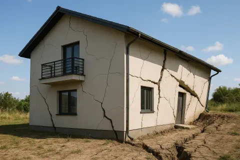
How an incorrectly defined foundation level becomes a construction problem
The relationship between foundation level and budget is direct and brutal. Every additional metre of depth means more excavation, more concrete volume, more working time and, in some cases, the need for shoring (trench support) or pumping out water. In a standard single-family home, the difference between founding at 80 centimetres and founding at two metres can account for between €8,000 and €18,000 additional cost in the construction budget.
When the foundation level is deeper than planned
It is the most common and the most expensive scenario. The report did not specify the foundation level or estimated it vaguely; the architect calculated the foundations at a reasonable depth based on their experience in the area; and during excavation, the competent ground appears deeper than expected. The works stop, the calculator/design engineer must resize, the contractor renegotiates prices, and the owner bears an extra cost that nobody had budgeted.
When there is variability between points
On plots with irregular stratification, the foundation level can vary between different areas within the same building footprint. One end of the house may need to found at 1.2 metres, while the other end needs to reach 2.5 metres. If the report does not reflect that variability clearly, the foundations are designed uniformly and execution leads to conflicts and unforeseen adjustments.
"The foundation level is not an indicative recommendation: it is the piece of data that turns the geotechnical report into an engineering document with real consequences for safety and
When the foundation level cuts into the groundwater table
If the foundation level determined by stratification coincides with or lies below the groundwater level detected in the trial boreholes, the works require waterproofing and drainage measures that are not always budgeted. Founding in the presence of water without the appropriate measures is one of the most common causes of pathologies in basements and ground-floor levels.
👉 How many trial boreholes does my plot need for the geotechnical study?
KEY DATA: In projects where the foundation level was not correctly defined in the geotechnical report, the average overrun for unforeseen events during excavation and foundation redesign lies between 15% and 35% of the initial structure budget. For a home with a structural budget of €80,000, that means between €12,000 and €28,000 not foreseen.
The case of the house that ended up with no basement
On a plot in the Sierra de Guadalajara, a couple had designed their home with a basement for a garage. The geotechnical report they had commissioned indicated favourable ground without specifying the foundation level explicitly. The architect interpreted that they could excavate down to the planned basement level, at three metres depth.
At 1.8 metres, rock appeared. Not the type of rock that ideally forms competent ground, but an outcrop of fractured granite with pockets of clay between the discontinuities. Excavating in rock required equipment that the contractor had not arranged: a breaker hammer, management of special waste and a cost overrun of €14,000 just for excavation. The basement was removed from the design to avoid that cost, which forced a complete redesign of the layout of the home.
A geotechnical report that had included the foundation level with precision —and that had warned of the presence of rock at less than two metres— would have allowed that decision to be taken in the architect’s office, with time and without pressure. Instead, it was taken with the excavation machinery stopped and the contractor waiting.
👉 Who signs the geotechnical report and why does that signature change everything?
"Removing a basement from a house because the ground did not allow it was a perfectly valid decision. Making that decision with the works already started, on the other hand, was one that cost time, money and a complete redesign."

Three signs that your report does not define the foundation level properly
Before you consider the geotechnical report valid and pass it to your architect, check that it does not include any of these three common errors:
- Vague wording without a specific depth. Statements such as "it is recommended to found on the competent stratum" or "the foundations shall reach the level of gravels" without specifying a depth in metres are unacceptable. The report must state an explicit numerical foundation level, referenced to the ground formation level or to a fixed point on the plot.
- A single foundation level for the entire plot without justification. If the trial boreholes show stratigraphic variations between points and the report proposes a single foundation level for the whole building footprint, you need to ask why. In homogeneous ground it is reasonable; in ground with lateral variability, it is a simplification that can cause problems on site.
- Absence of reference to the groundwater table in relation to the foundation level. If the report detects groundwater but does not explicitly relate that level to the recommended foundation level, critical information is missing. Your architect needs to know whether they will found above the water, at the same level, or below the water in order to correctly size the necessary construction measures.
The figure that really defines where your house begins
Ultimately, the foundation level is the answer to a very specific question: how far down must you dig for the footings of your home to be on safe ground? It is a number. One and a half metres, two metres, three metres. But that number has consequences that extend across the entire construction budget, across structural design and across the safety of the building for decades.
When that number is correctly defined in the geotechnical report, your architect can calculate accurately, your contractor can budget without excessive uncertainty margins, and you can plan your works without fear of surprises under the ground. When it is not defined or is badly defined, all those certainties disappear and you, the owner, assume the risk.
The next step is to verify that your report includes that data explicitly. If you do not have it yet, this is the time to request it before any other professional on the works begins making decisions without it.
Request a geotechnical report by filling in the form →
Do you need a geotechnical study?
Request a no-obligation quote. We’ll advise you on the type of study you need.
- Studies signed by a licensed geologist
- Compliant with the CTE and Eurocode 7
- Coverage throughout Spain


Más de 1000 estudios realizados
Request a free quote
We can contact you via WhatsApp, phone, or email, whichever you prefer.


