Llíria turned a hill into a capital and later opened the waterway toward the huerta
From the Tosal de San Miguel, ancient Edeta dominated the territory that now stretches around Llíria. The sloping shape of the piedmont helps explain how that political center eventually became linked to a huerta organized by irrigation channels.
From the Tosal de San Miguel, about 500 meters from Llíria’s historic center, the view reaches across a plain that descends toward the Turia. Edeta, the Iberian city that was the capital and political and economic center of Edetania, was located there. Much later, water began to organize that same space in a different way: the irrigation channels and irrigated agriculture transformed the piedmont into a huerta on which a large part of local life depended.
The scene brings together two different human decisions. First, the choice of an elevated site for establishing the territory’s main Iberian settlement. Later, the adaptation of the population to a surface that descends from the mountains toward the river and allows water to be conveyed along the slope. Geology does not by itself explain the emergence of Edeta, but it does provide the physical setting in which the city, roads, crops, and irrigation could interact.
A city built on the piedmont
The municipality of Llíria occupies an inclined plain extending from the mountains of Alcublas and Marines to the left bank of the Turia River. The elevation falls from 350 meters at Masía del Campos to around 150 meters near the town. It is not a perfectly horizontal plain, but a transitional surface between the mountains and the river corridor.
That difference in elevation matters. On sloping terrain, rainwater naturally seeks the lower elevations, while channels and ravines can concentrate runoff. For an agricultural community, the slope can be an obstacle if water is quickly lost, but it can also be an advantage if channels are built to distribute it. The shape of the piedmont probably conditioned how the territory was occupied and worked, although the available sources do not allow geology to be credited with a specific decision concerning Edeta’s location.
The Tosal de San Miguel nevertheless offered a distinct position within this landscape. The Iberian city was not at the bottom of the plain, but on an elevation recognizable from the surrounding area. This position may have facilitated visual control of the territory and the routes crossing it, but a reasonable possibility should not be turned into a documented certainty. What is documented is Edeta’s importance: during the first and second centuries, it played a leading role in Edetania.
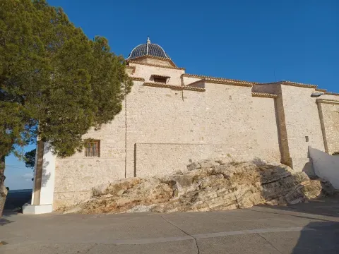
Exterior del Real Monasterio de San Miguel de Llíria, situado en la elevación que domina el paisaje local.
From political center to a water network
The history of the site did not end with the decline of the Iberian city. Edeta’s importance diminished from the third century onward and in the following centuries, alongside the growth of Valentia. During the Visigothic period, the Mura baths were reused as a Christian monastery, while the settlement at Pla de l'Arc was eventually completely abandoned in the seventh century.
The territory, however, remained usable. Under Muslim rule, the irrigation channels and the irrigation system of Llíria’s huerta were improved. The transformation was profound because it shifted the focus from the inhabited elevation toward the productive surface spreading out at its feet. The relief ceased to be merely a form that allowed the surroundings to be dominated; it began to organize the movement of water and the distribution of crops.
The relationship between water and terrain can be understood without imagining an isolated hydraulic work. An irrigation channel requires a gentle, continuous slope; if the terrain rises and falls unpredictably, the water stagnates or overflows. In the Llíria piedmont, the general inclination toward the southeast provided a natural direction for these routes. Geology therefore suggests a condition of possibility, not a complete explanation: it was human communities that laid out, maintained, and improved the channels.
The contrast between a city established at elevation and a huerta spread across the slope summarizes the change. Edeta concentrated power at a high point; irrigation distributed opportunities across a much larger surface. Between these two ways of occupying Llíria lay centuries of political, religious, and economic transformations, but the same physical framework remained.
The rocks that support the landscape
The geotechnical data available for the municipality show a majority presence of limestones, dolomites, and marbles, together with gypsum, anhydrite, and salts, as well as sandstones, conglomerates, clayey materials, and silts. Not all of these materials necessarily occur at the Tosal de San Miguel or independently explain Llíria’s historical trajectory. More modestly, they help show that the municipality contains different substrates and that water behavior may vary from one area to another.
Carbonate rocks, such as limestones and dolomites, originally formed in warm, shallow marine environments comparable to a tropical coastal platform. Over time, these materials became integrated into the present-day relief. In some carbonate formations, water can infiltrate through cracks and create karst systems; on other surfaces, fine materials hinder circulation. This diversity helps explain why water management requires knowledge of the terrain, although it does not justify attributing each irrigation channel or crop to a particular rock.
Groundwater is also part of the municipality’s subsurface. The boreholes compiled for Llíria reach very different depths and record varying water levels depending on the location. This information describes a heterogeneous territory, not a single uniform reservoir. For local history, its value lies in reminding us that the relationship with water did not depend solely on visible waterways: it was also conditioned by what was happening below the surface.
A huerta that extended the occupation of the territory
During the eighteenth century, the physiocratic policies of the Bourbons drove a spectacular expansion of agriculture in Llíria. Agricultural expansion gave a new dimension to the irrigation network and to the productive area situated between the mountains and the Turia. The piedmont, previously described as a simple landform, became an intensively cultivated surface.
Continuity should not be confused with immobility. Edeta was an Iberian capital; the Mura baths changed function; Pla de l'Arc was abandoned; the Andalusi irrigation channels reorganized the huerta, and modern agriculture increased its importance. Each period used the territory in a different way.
When you look today from the heights of Llíria toward the plain, you can read this succession even though it is not written on a single stone: above, the site of the Iberian city; below, the inclined plane leading toward the Turia; between them, a long history of human intervention to make water flow. Ancient Edeta and the huerta are not the same landscape, but they share the same physical foundation.
Llíria grew between an elevation chosen to concentrate power and a slope transformed into agricultural space. Rock and relief did not determine the city’s course, but they offered the conditions that each society reinterpreted in its own way. That is why the Llíria landscape preserves two superimposed movements: the view from the Tosal and the water descending toward the huerta.
Do you need a geotechnical study in Llíria?
Request a no-obligation quote. We’ll advise you on the type of study you need.
- Studies signed by a licensed geologist
- Compliant with the CTE and Eurocode 7
- Coverage throughout Spain


Más de 1000 estudios realizados
Request a free quote
We can contact you via WhatsApp, phone, or email, whichever you prefer.


