Ames, the valley where the water had to coexist with the new town
The bridge crosses a watercourse while, behind it, the façades of Bertamiráns form an urban line that seems not to have been there for long. Under the grass, the paths and the buildings there is low-permeability ground, made up mainly of sandstone, conglomerates, flysch, slates and schists, which helps to explain why the water remains visible as Ames is transformed. Following that small channel makes it possible to read the transition from a valley-and-parishes territory to one of the most dynamic residential areas in A Coruña.

El puente sobre el curso de agua en Bertamiráns, con el paseo y las viviendas al fondo, resume el encuentro entre el valle y la ciudad reciente.
The bridge crosses a watercourse while, behind it, the façades of Bertamiráns form an urban line that seems not to have been there for very long. Under the grass, the paths and the buildings, there is low-permeability ground, composed mainly of sandstone, conglomerates, flysch, slates and schists, which helps to explain why the water remains visible while Ames is transformed. Following that small channel makes it possible to read the transition from a valley territory and parishes to one of the most dynamic residential areas of A Coruña.
The bridge does not tell the whole story
From the footbridge, the scene appears straightforward: a sheet of water, a tree-lined walkway, a road that passes over it, and dwellings of several storeys in the background. But that simplicity is recent. The bridge belongs to an Ames that has turned the edges of the water into public space and that has made Bertamiráns a place for living, movement and services. To understand how things have come to be like this, it is necessary to look in two directions at the same time: towards the valley that organises drainage, and towards the subsurface that conditions how water moves.
The available geotechnical study divides most of the identified materials into two main groups. The most extensive brings together sandstones, conglomerates and flysch, accounting for 66,58 % of the surface area considered; the other 25,97 % corresponds to slates and schists. These are not interchangeable names. Sandstone is a rock formed by cemented sand grains; conglomerate contains coarser fragments; slates and schists show planes that may facilitate fracturing. Flysch, for its part, refers to a stratified succession of materials that does not respond uniformly to erosion or to water.
The important consequence for this story is not memorising the list, but observing that the ground does not provide a single response. Some surfaces may withstand conditions better, others become altered or erode more easily, and water may circulate in a limited way through sound rock but find local routes through alteration and fractures. The geotechnical classification describes, in general, formations that are impermeable or of very low permeability, although capable of hosting small superficial aquifers where the rock is altered or fractured. This combination helps to understand the landscape: water does not necessarily disappear underground nor does it have a large continuous underground reservoir; it may concentrate in modest channels and reappear at specific points.
This is where the causal relationship of interest begins. The valley offers a more accommodating surface for travelling through, occupying and connecting; the low-permeability subsurface makes it more likely that runoff remains visibly present and that the watercourses continue to be elements that urban development must cross, channel, respect or turn into a walkway. It cannot be stated that the first inhabitants chose Ames because of this specific geological composition. What can be said is that physical conditions help explain the problems and opportunities that emerge later, when settlement grows and water ceases to be only a local resource and also becomes a matter of urban design.
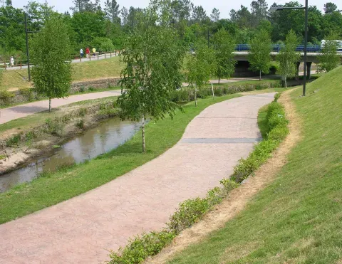
El paseo acompaña al cauce y mantiene una franja abierta entre la corriente, la vegetación y las nuevas áreas urbanas de Bertamiráns.
A name that was already there before the city
Medieval documentation does not describe a compact city like the one seen today in some sectors of Bertamiráns. What it does provide is a sign of territorial continuity: the place name Ames appears from the 12th century in different forms. The Tumba de Toxos Outos records it in 1143 as “Sancti Thome apostoli de Oliames”; afterwards, Oyames and Oiames appear as well, again in documents from the 12th and 13th centuries. The linguistic evolution that interprets the initial vowel as an article and explains the loss of the i speaks of a named community, recognised and transmitted across generations.
A place name is not a founding charter and, by itself, does not allow the first settlement to be mapped. But it does change the way the landscape is viewed. Before there were blocks of housing, wide streets and concrete bridges, there was a network of parishes, paths, worked lands and places identified by their inhabitants. The valley was not an empty space waiting for urban expansion: it was a territory inhabited in another way, at a smaller scale and with a more direct relationship to water and slopes.
Location within a valley also contributes to a mild climate in winter and hot summers, according to the description of the municipality. It is not a single explanation for historical occupation, but it is a condition that makes the continuity of settlement, and the later residential attraction, easier to understand. The topography brings together a certain degree of climatic protection within the same space, relatively straightforward routes and watercourses that organise drainage. Geology does not decide for people, but it sets the framework within which decisions have different costs and benefits.
In Ames prior to recent expansion, architecture also shows how a society turns the territory into hierarchy. The Casa de Sandar, in Agrón, preserves the character of a medieval noble house; the Pazo de Leboráns, in Trasmonte, belongs to 18th-century seigneurial architecture; and the Pazo da Peregrina, in Bertamiráns, was linked in that same century to the Piñeiro and Lago family and then to their descendants. These are not buildings that can be explained solely by the rock beneath their foundations. They represent power, ownership and social organisation. But they are set within a landscape of parishes and paths where slopes, passages and water condition how to reach, produce and build.
Stone becomes visible in the church
There is a way to approach the geology of Ames without looking at a road cutting: to observe how architecture turns stone into surface, corner and volume. The parish church of Santo Tomé de Ames is a Baroque building built in granite ashlar and topped by a central tower. The historical source does not allow it to be affirmed that this granite came from a specific quarry in the municipality, but it does document a material decision: a resistant rock is transformed into a building that had to remain, mark a place and withstand the passage of time.
The difference between this building and the landscape of the channel is revealing. In the church, the stone appears selected, cut and ordered by the stonemasons. In the valley, materials act in a less visible way: they absorb, retain, transmit or divert the water; they provide surfaces that are more or less stable; they respond differently when a road is opened or a foundation is built. The locality is constructed with both scales at the same time. Architecture shows human work on matter, while the ground imposes the initial conditions for that work.
Sculptural elements dating back to the 14th century and noble houses from later periods add layers to that occupation. Ames is not the result of a single foundation or a single monument. It is the superposition of religious places, seigneurial properties, villages and road connections over a relief that remains while its uses change. The current that today accompanies a walkway may have long been a practical boundary, a point of passage, or a reference for dividing plots. The available documentation does not identify each of those functions, but the persistence of settlement makes it possible to see that the territory has been reused, not completely replaced.
When Santiago drives growth towards the valley
The decisive transformation comes in the 1980s. The proximity to Santiago de Compostela and the price of housing, which is lower than in the Galician capital, drive the emergence of a new residential stage. The change is not only that the number of inhabitants increases. The scale of the territory changes: more dwellings appear, more journeys, more need for streets, bridges, sewerage and meeting spaces.
This is the point at which the valley acquires a new value. Proximity to Santiago is the documented factor that explains the attraction; relief and the drainage network provide the physical support on which that attraction becomes real. Where previously local paths and small crossings were enough, the residential city needs infrastructures capable of bridging the watercourses and organising growth. A bridge no longer serves only so that someone can move from one bank to the other: it integrates the channel into a much more intense circulation network.
If you look at the image of the channel from the walkway, several simultaneous decisions can be recognised. The water retains an open space; the banks are treated as a park; a road runs over it; the dwellings are built behind it. This composition is neither untouched nature nor urban development that completely erases the stream. It is a negotiation. The city needs land and connections, but the water continues to occupy the low point reached by drainage from the nearby surface.
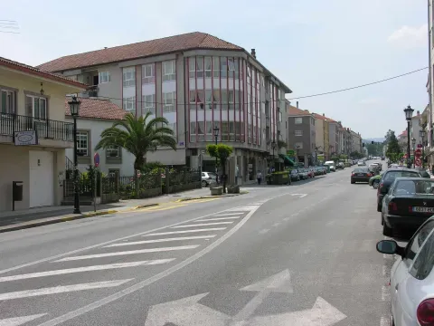
La avenida de Bertamiráns muestra la escala de la expansión urbana que acompaña al crecimiento residencial de Ames desde los años ochenta.
The behaviour of the subsurface returns here as a practical condition. In formations that are generally impermeable or of very low permeability, rainwater may circulate over altered surfaces and concentrate in depressions and channels. The aquifers that appear due to alteration or fracturing tend to be limited in extent and of low productivity, although they may be of local interest. For a city, that means that surface water and drainage are not secondary details. The works must convey the water without relying on the ground to absorb it uniformly.
The fluvial park of Bertamiráns — visible in images as a sequence of grass, paths and small steps — can be read as a transformation of the water edge. There is no documentary basis to attribute its design exclusively to geology. Its existence belongs to contemporary urban development and to the creation of public spaces. But its form is consistent with a physical condition that forces the route of water to remain visible and manageable. The infrastructure does not eliminate the channel: it incorporates it into the new city.
The soil that is not seen also decides
Residential expansion often tells its story through façades, cranes and new roads. In Ames, there is another story beneath them. The geotechnical information does not identify expansivity-related hazard: the substratum is classified as non-clayey. This reduces the relevance of the typical problem of some clayey soils, which can swell and shrink with changes in moisture. This does not mean that every plot is identical nor that all construction difficulties disappear, but it does mark a difference compared with a territory dominated by expansive clays.
The main difficulty that stands out is another: there are areas with present or potential slope movement of the landslide and rockfall type. In a municipality with slopes, paths and building expansion, this warning requires observing how the ground is cut. A slope does not behave in the same way when it retains its ground cover and drainage as when it is excavated, loaded with an edification or receives a road. Alternation of materials and the presence of altered or fractured rock can lead water to find weak planes or concentrated flow routes. Geology becomes a project issue again: where to found, how to evacuate water and how much to modify a slope.
Low permeability also does not equate to the absence of groundwater. The study indicates that alteration and fissures may host superficial aquifers, generally limited and of low productivity. It is a different picture from that of a large underground reservoir. In Ames, water may have a highly localised importance: a spring, a small channel, a resurgence or a damp stretch may depend on a specific combination between rock, fractures, soil and slope.
Springs of Castrigo, also represented in Ames’s visual heritage, remind us of that smaller scale. A spring is not only a construction: it is the point at which a society collects and orders water that has found an outlet. The stone material of the structure, the channel and the wash area make visible a process that is normally hidden. The spring turns the movement of water into everyday infrastructure, in the same way that the contemporary bridge turns the channel into part of an urban network.
Ground types in Ames
Characteristic soils in the area, ordered by relevance.
-
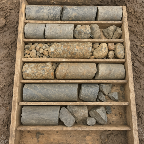
Sandstones, Conglomerates and Flysch
Sedimentary rocks formed by the cementation of fragments of other pre-existing rocks. They include sandstones (cemented sand), conglomerates (cemented gravels) and the rhythmic alternation of sandston
View details -
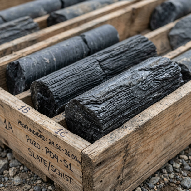
Phyllites and schists
Metamorphic rocks characterised by their foliation (parallel planes of weakness or slaty cleavage). Very common in Galicia, Asturias, the north of León, Extremadura and Sierra Morena. They are highly
View details
From parishes to the services municipality
The population of Ames increases steadily during recent decades and the municipality receives families from other parts of Galicia, Spain and other places in the world. The territorial consequence is a mixture of times: alongside houses and pazos that preserve the memory of rural and seigneurial organisation, there are blocks, shops, roads and facilities linked to metropolitan life in Santiago.
Work also changes. Occupation data bring together close to 200 people in agriculture, around 20 in fishing, about 1,000 in industry, close to 1,000 in construction and more than 6,000 in services. The figures do not describe by themselves the spatial distribution of each activity, but they do show the shift of an economy in which agricultural land had a direct weight towards another in which mobility, housing, construction and services are central.
This shift does not erase the physical base. Agriculture needs land, water and manageable slopes; construction needs stable ground and drainage systems; services need streets, car parks and connections. The same plain or valley may serve successively for producing, crossing, building and creating a park. Each use requires a different intervention. Urban expansion does not arrive at a neutral territory, but at one that already has runoff routes, more resilient areas, altered materials and points where a slope can move.
In this sense, Ames offers a lesson about the dispersed Galician city. Proximity to Santiago triggers growth, but it does not fully determine its form. Infrastructure has to adapt to watercourses and changes in level; dwellings fit themselves to plots and roads; public spaces make use of or protect wet corridors. The metropolitan economy accelerates change, while relief and the subsurface impose pauses, diversions and costs.
A seismically discreet but not immobile territory
The seismic activity recorded over the thirty-year period covered by the study also does not provide a catastrophe narrative. There are 21 events of magnitude between 1,5 and 2,2, with a maximum of 2,2. These are low values and they do not explain the urban form of Ames. Its interest lies precisely in putting risks into proportion: the municipality is not understood in terms of major earthquakes, but rather through more ordinary and persistent processes such as water, alteration of the rock, erosion and slope stability.
The difference matters. A city can coexist for decades with small seismic movements without these marking its streets, whereas poor drainage management can affect a specific structure much more immediately. The ground often acts through slow processes: a slope that loses support, a cut slope that saturates, a surface that concentrates runoff, or a fractured rock that offers water a preferred path. These are less spectacular phenomena than an earthquake, but closer to day-to-day planning.
Back to the bridge
Now the initial scene can be read in another way. The bridge is not simply placed over a thread of water: it resolves the meeting between a persistent channel, ground that does not absorb uniformly, a network of paths and a city that has grown in the heat of Santiago de Compostela. The park around it is not only a green area. It is the space that remains and is designed around a physical condition that urban development cannot erase without assuming new problems.
Medieval Ames appears in the documented name from the 12th century; seigneurial Ames remains in its pazos and houses; religious Ames is recognised in the stone of Santo Tomé; contemporary Ames is seen in the housing, the roads and the services of Bertamiráns. All of them occupy the same valley, although each period uses it differently. People change the boundaries, materials and functions, but the water keeps looking for its way between the rocks and slopes.
That is why stopping by the bridge is enough to see the full story in miniature. The current sets the scale of the landscape; the footbridge turns the obstacle into a connection; the buildings announce residential transformation; and the subsurface reminds us that every extension must negotiate permeability, fractures and stability. Ames does not grow away from its ground. It grows by learning, sometimes in a visible way and sometimes underground, where the water can pass.
Do you need a geotechnical study in Ames?
Request a no-obligation quote. We’ll advise you on the type of study you need.
- Studies signed by a licensed geologist
- Compliant with the CTE and Eurocode 7
- Coverage throughout Spain


Más de 1000 estudios realizados
Request a free quote
We can contact you via WhatsApp, phone, or email, whichever you prefer.


